The History of Culebra Island and Its Surroundings

East of mainland Puerto Rico and northwest of Vieques, the small, hilly island of Culebra sits amid clear shallows and reef gardens that have shaped every chapter of its story. Today, names like Flamenco Beach, Tamarindo, and Zoni evoke lazy swims and postcard hues, but Culebra’s identity was forged long before beach towels—by maritime routes, resilient settlers, a rugged coastline, and the sea itself. This is an island where history is written in coral heads, goat tracks, and the quiet of a natural harbor at dawn.
Islands at a Crossroads
The Spanish Main and the Lesser Antilles meet in the currents around Culebra. For centuries, sailors threaded these channels to trade, fish, or seek shelter from Atlantic squalls. The island’s coves—compact, irregular, and blessed with lee-side protection—offered anchorages that could be defended with modest effort. That geography shaped settlement patterns: simple coastal paths linked water sources to beaches and lookout points, while small vegas in the valleys supported fruit trees, root crops, and a handful of livestock. The sea provided the rest: fish, conch, and a highway to nearby islands.
From Outpost to Community
As colonial influence grew, Culebra remained peripheral but useful—an outpost for fishermen, a waypoint for coastal patrols, and a refuge when storms closed the wider sea. Over time, families established homesteads near protected bays, and a small administrative center evolved where boats could reliably land. Unlike larger islands where plantations dominated, Culebra’s thin soils and fractured terrain discouraged monoculture, keeping communities small, dispersed, and intimately tied to the water. The rhythm of life followed the tides: mending nets at sunrise, ferrying goods at slack water, and gathering under sea grape shade when the trades blew strongest.
Military Footprints and Their Echoes
The 20th century brought a new chapter as portions of Culebra and neighboring islets saw military activity. Traces of that period linger in scattered concrete, weathered foundations, and stories passed among elders about exercises that once echoed across otherwise quiet hills. In later decades, public advocacy and changing defense priorities shifted the island’s trajectory. Land returned to civilian use and sensitive areas moved toward conservation, allowing reefs and beaches to reclaim their central role. The arc from strategic outpost to protected natural sanctuary is one of Culebra’s defining transformations.
Reef, Seagrass, and the Aquarium-Clear Shallows
Culebra’s reputation as a snorkeler’s and diver’s haven springs from its underwater architecture. Patch reefs fringe many shores; coral heads break swell into a rhythmic hush; and broad meadows of seagrass host green turtles that graze in unhurried loops. These habitats work together: reefs blunt the sea’s energy, sand settles in long crescent beaches, and grass binds the bottom into calm, transparent shallows. In coves like Tamarindo and along the shoulders of Flamenco, beginners can float over schools of grunts and juvenile parrotfish, while more experienced explorers fin toward spur-and-groove formations where the Atlantic’s breath is felt in slow, steady pulses.
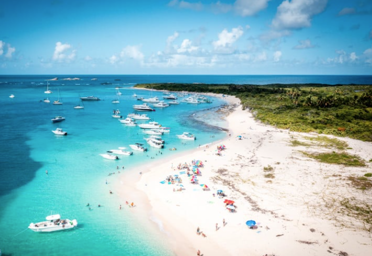
Flamenco Beach: From Working Cove to Icon
The sweep of Flamenco Beach is the island’s best-known postcard: powder-fine sand, turquoise water, and a mountain backdrop that folds gently to the sea. Long before lifeguard towers and kiosks, this was a working cove where boats were hauled out and gear was stored under palms. Over time, as travel links improved and conservation efforts matured, Flamenco evolved into a carefully managed public beach that balances access with protection. Boardwalks steer feet off fragile dunes, facilities cluster where impact can be absorbed, and clear signage reminds visitors that the same calm water that invites a swim is held together by living reef.
Town, Ferries, and the Island’s Social Heart
The compact town—often referred to simply as Dewey—grew around a protected channel that splits Culebra from the islet of Luis Peña. Ferries, small cargo boats, and private craft thread this water daily, bringing supplies, family visits, and the pulse of the wider archipelago. Streets near the dock carry the island’s social rhythm: groceries and bakeries opening early, cafés trading weather notes with captains, and evening strolls that end at the water’s edge. Festivals, school events, and fishermen’s returns turn the waterfront into a living plaza.
Conservation Mindset and Everyday Stewardship
Culebra’s modest size makes cause and effect visible. When visitors stick to marked paths, dunes heal. When divers watch their buoyancy, corals thrive. When boaters respect mooring fields, seagrass meadows stay intact for turtles and rays. Local and regional groups coordinate cleanups, reef-monitoring dives, and signage that promotes reef-safe sunscreen and leave-no-trace practices. If the island feels unusually pristine, it’s because many hands keep it that way—residents who remember leaner years and newcomers who came for clear water and stayed for the community that protects it.
Storms, Resilience, and the Long View
Hurricanes have always been part of the island’s calculus. Winds topple palms, surge redraws beaches, and debris can clog lagoons. Yet the same reefs that slow daily swell help blunt storm energy, and the hills re-green with surprising speed. Recovery is local and practical: clearing piers, checking channel markers, repairing boardwalks, and reopening schoolrooms so normal life can resume. Over decades, Culebra has learned to bend with the weather without breaking—another reason its small population speaks of the island with a blend of pride and gratitude.
Reading the Island Like a Timeline
To visit Culebra is to walk through layered history at human scale. Stand at Flamenco at sunrise and you see geology’s patient architecture. Drift over seagrass and you watch an ecological engine at work. Share a bench near the ferry and you hear a social story told in arrivals and departures. Hike a low ridge and an inlet opens like an invitation—proof that for all the talk of remoteness, Culebra’s heart beats at the edge of the sea. The island’s past and present meet where a skiff noses into a quiet cove and someone on shore lifts a hand in hello.
In the end, Culebra’s history is a compact epic: outpost, home, training ground, sanctuary—each chapter shaped by the same clear water and protective reefs. Care for those foundations, and the island keeps its promise: an isla chiquita with a big, blue horizon where the next page is written in soft sand and slow tides.
Tip: Arrive early for calmest water and the gentlest light on the reefs; bring a mask, tread lightly on dunes, and let the island’s small scale set your pace.
RELATED ARTICLES